Northern Territory
Physical Description
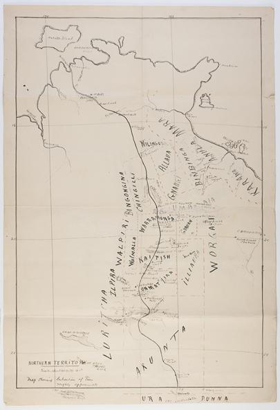
Hand-drawn map of the Northern Territory with lines of latitude and longitude; ink on thick paper. The map covers an area north of Oodnadatta (bottom edge) and inscribed with names of places and groups. Annotation bottom left. Worn along folds in the paper sheet, with small tear upper right edge.
Primary Comments
The map identifies 'roughly approximate' boundaries of 22 Aboriginal groups as far south as Oodnadatta, and north to Roper River.
Images
- MV.CollectishPlatform.Common.Entities.ImageFileDetails. http://spencerandgillen.net/media/collectors/4fac697e023fd704f475b34f/items/50ce72f4023fd7358c8a9458/50d0ae2e2162ef0b7839313c/SpencerAndGillen-large.jpg
- MV.CollectishPlatform.Common.Entities.ImageFileDetails. http://spencerandgillen.net/media/collectors/4fac697e023fd704f475b34f/items/50ce72f4023fd7358c8a9458/50d0ae352162ef0b78393141/SpencerAndGillen-large.jpg
Rights: Museum Victoria
Document Details
- Date Made
- Between 1901 and 1904
- Creator
Document Details
- Number of Pages
- 1
- Number of Sheets
- 1
Subjects
- Language Groups
Institution
- Institution
- Museum Victoria
- Registration
- XM5955
Classification
- Primary Subject
- Localities, Tribal Boundaries